The facts
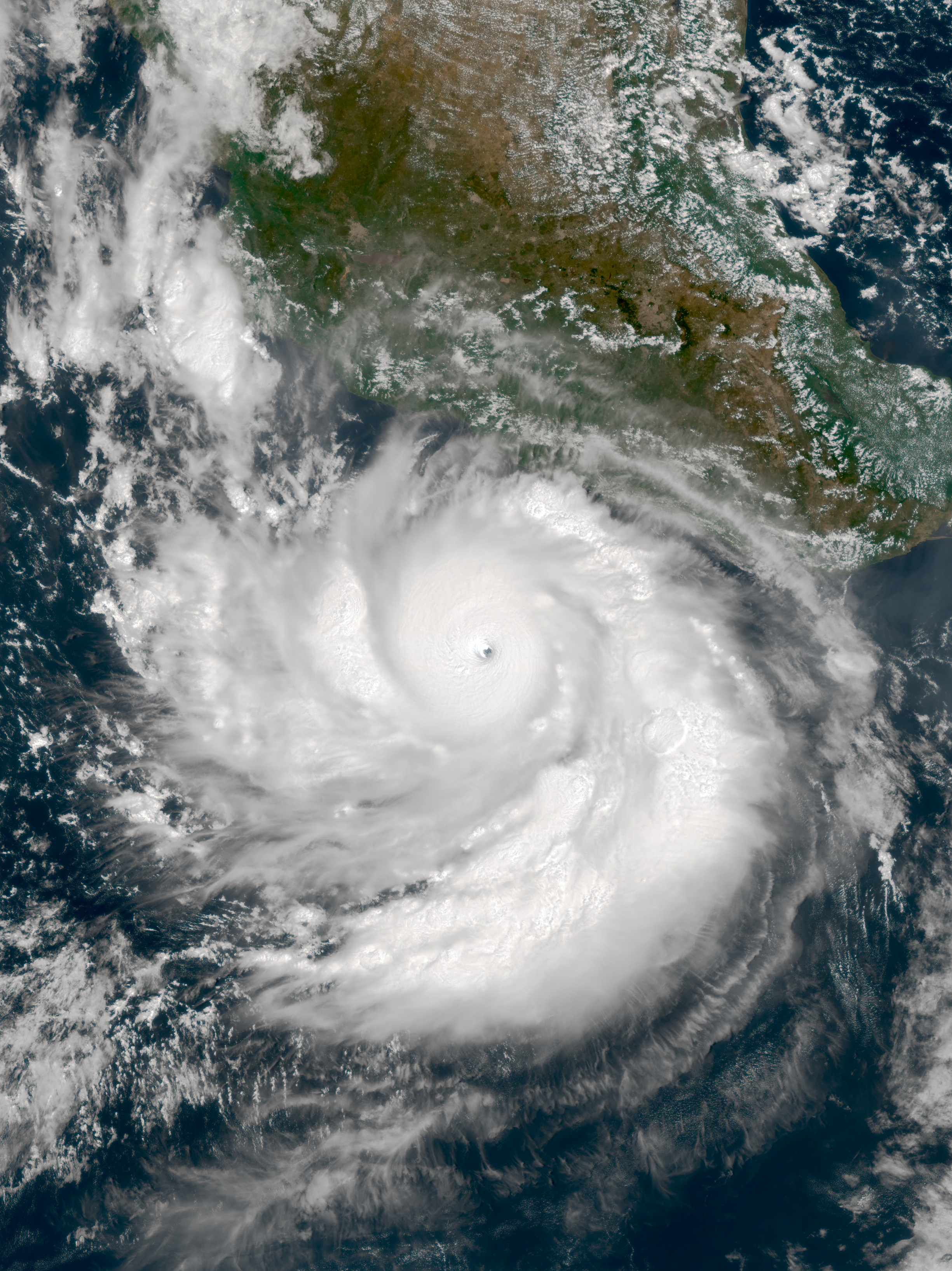
In mid-September 2026, Hurricane Polo rapidly intensified off the Pacific coast of Mexico, a process described by atmospheric scientist Gary Partyka of NASA's Goddard Space Flight Center as "explosively rapid intensification." This phenomenon, technically classified as extreme rapid intensification when wind speeds increase by at least 60 knots (111 kilometers per hour) in 24 hours, saw Polo's winds increase by 90 knots (167 kilometers per hour) within a 24-hour period, reaching Category 5 strength. On September 22, NOAA's Hurricane Hunter aircraft estimated winds near 285 kilometers per hour, potentially making it the third-strongest storm on record in the eastern Pacific and the fastest to go from a tropical depression to a Category 5 storm. By September 23, when NASA's Aqua satellite captured an image, Polo was a Category 4 storm with sustained winds of 230 kilometers per hour, having undergone an eyewall replacement cycle. Atmospheric scientist Kristen Corbosiero noted that weak upper-level winds and good outflow contributed to the storm's intensification. Polo developed over sea surface temperatures as high as 32 degrees Celsius (90 degrees Fahrenheit), warmer than average, with high ocean heat content at considerable depths. While not directly attributed to El Niño, the overall tropical cyclone activity in the eastern Pacific was nearly twice the norm in 2026.
Our take
Hurricane Polo didn’t just intensify. It pulled a goddamn Bruce Banner, hulking out from a tropical depression to a Category 5 monster in the time it takes to binge a shitty Netflix series. Winds cranked up by 167 kilometers per hour in a day. That’s not ‘rapid intensification,’ that’s the atmospheric equivalent of slamming a cartoon rocket into a stationary bicycle. Scientists called it ‘explosive’ and ‘jaw-dropping,’ which is just polite lab-coat speak for ‘what the fuck is happening?’
The ocean served as its personal steroid buffet. The water Polo formed over was a bathtub-hot 32 degrees Celsius, with that heat stretching deep. It’s like the Pacific looked at a hurricane and said, ‘You know what? Here’s a fucking bottomless espresso shot of fuck-you energy.’ Weak upper-level winds meant nothing was there to give this asshole a reality check, letting it gorge itself into a historic fit.
By the time the Hurricane Hunter planes caught up, Polo was boasting winds near 285 kph, potentially making it the third-strongest eastern Pacific storm ever recorded. Then, in a final act of meteorological vanity, it underwent an eyewall replacement cycle - because even a planet-killing vortex needs a little cosmetic restructuring. It ‘weakened’ to a mere Category 4, a pit stop of 230 kph winds, just to flex on the satellites.
The broader context is a gut-punch: 2026’s eastern Pacific cyclone activity was nearly double the norm. While not directly pinned to El Niño, the message is clear. The baseline for ‘normal’ is now a fever dream, where storms can achieve in a day what used to take a career. Polo isn’t an anomaly; it’s a fucking preview. The ocean’s open bar for hurricanes is now permanently stocked, and the next patron is already lining up.